Saturday, June 14, 2014

North Country Trail Affair

In my love affair with the Appalachian Trail, we have an open relationship.  I'm ok with millions of people treading on her and she lets me see other trails.  

So, with that established, on the early morning of May 11th, Alex and I packed up the truck and headed five hours over to Western PA to the Allegheny National Forest.  Here is where the North Country Scenic Trail works its way through the northern parts of Pennsylvania on its way to Ohio and beyond. 

Alex and I arrived at my brother's cabin near Tionesta sometime after noon and we spent the day, catching up with my brothers Mart and Tom, Marty's wife Michele and daughter Allie and also with my cousin John, who lives just down the road, drinking some beer and cider and eating fresh picked Morel mushrooms.  Turk, (aka Kangaroo Joe) was also there.  He would make up the third of our little backpacking group.


Practice makes perfect
Hikers
Allie Bubble Girl
Homemade hard cider
Tom
We had been planning this little outing since the winter months.  Our plan was to hike four days for a total of somewhere around 30 miles.  This wasn't the AT.  I would find out, it was much more remote.

On Monday morning, we were all up and on the road by 7:15.  John was taking us to our drop off point at Henry Mills along Route 666 and would be picking us up at Cougar Bobs in Kellettville in four days.  


Ready to go
Go this way...
On the way to the dropoff, we saw two Bald Eagles sitting in trees near the Creek.  A good omen in my book.  We hit the trail at 0813.  The beginning was a fairly steep climb up from the road onto the ridge.  It was mostly on old forest roads and pretty easy to walk.  We kept passing lots of old machinery along the way.  There has been lots of oil drilling in the area for years.

There are a lot of Geocaches along the trail and I had put about 30 of them in my GPS.  I couldn't get a good lock on the climb up the ridge, so I turned the device off for a while and kept on walking.  We took a break around 1000 and I turned it back on.  I got a lock and saw that a cache was just .2 away.  After the break I headed along and found the cache quickly. 

Our first day was planned to be a comfortable length and we were at Hunter Station Shelter around 11:15, just in time for lunch after about 5.8 miles.  After checking out the area, I found what I thought was a nice place for my hammock and set it up only to see a large widow maker right above me.  I moved to a different location and there would be my bed for the night.  The Upper Sheriff Run was flowing past in a babbling frenzy.  Just right for lulling you to sleep.
Hunter Station Shelter
I went back east to find a cache we had passed coming in and after a nice nap in the shelter, I walked about .8 up the trail to find my third cache of the day.  


Painted Trillium
During the day, I had been thinking of good trail names for Alex.  He was usually out front, being the young buck he is, and he carries a blue water bottle that I could see from time to time as I hiked behind him.  I started thinking of him as "Blue Blaze" until he missed a turn and walked off trail a bit.  

Alex also takes a lot of pictures and anyone who is his Facebook friend can see how good he is at framing a shot.  We made a few other suggestions on photography related trail names, one of them being "Snapshot".  

One other possibility came along when Alex realized he didn't bring a sleeping pad.  In our other hike, that was Shauni's job to carry the sleeping pads, while he carried the heavier stuff, so it slipped his mind that he needed one.  No problem for him, as he said he can sleep without one, but another trail name possibility "Padless" was thrown out there.

The day's wildlife included lots of Snake Sticks.  These vile creatures sit on the trail and jump up at you as you walk by, tangling in your legs and biting you with their woody teeth.  I also discovered and named another trail beast.  The Turtle Rock.  This badass will sit in the middle of the trail and wait for you to step on him, only to roll over and try to take your ankle with it.  I fearsome beast to be sure. 

We had a nice dinner and fire and around 8:30 pm the rain came in.  We all sat in the shelter as the rain came down rather heavy and at about 9:30 pm, I headed to my hammock to spend my night floating on air.  

Nice small creek coming into the run

My bed for the night
Wet morning
By morning the rain had pretty much stopped, but my tarp was, as expected, rather damp.  I had stayed high and dry throughout the night and slept pretty well despite the occasional thunder and lightning.  There was a rather loud and close crack right as I stepped out of my hammock in the morning, but by the time we headed out, the rain had stopped for the time being.

Once again we had a rather easy day.  About six miles were planned and we hoped to stay at the Triple Forks area of Minister Creek.  It is a popular place in the summer and has lots of places to set up.  

The day had turned pretty nice and before we knew it, we were heading down the ridge to the creek area.  We found a nice place to set up and I commenced to drying out my gear.  At this point I proposed the theory that all backpacking is, is getting yourself and gear wet and then drying it out again.  Sometimes during long trips, that separation can be days and days.  But for me, this day, it was only hours.  There was a nice breeze and before long I had all dry gear, including my shoes and we were all set up along another series of babbling brooks in a very nice area.  

During this day's hike, I couldn't find two caches.  I only look for a short time and if I don't find it within a few minutes, I move on.  I did see something showing in the woods as we neared the camping area and it did appear to be a cache, but it was in a different type of container.  I didn't take any notes on my DNFs, so I couldn't log them correctly as I couldn't remember which ones they were.  Also, I never could figure out if the one I did find was listed on the Geocache site.  I did find the one nearby the camping area pretty easy.  I think that was my 399th cache.  I was going for number 400 during this trip since I started this cool hobby.


Triple Forks Campsite
Grounders
As we were sitting by the fire, I spotted a porcupine walking on the other side of the creek.  Turk and Alex headed over to check it out and get some pictures.  I was more tired this night and headed to my hammock before 9 pm, read some and slept well till dawn.

I think the rain started around midnight and when we all got up there were still sprinkles in the air.  We broke camp carefully and headed up the trail with soggy gear once again.  

After we got moving the day became beautiful.  After hiking for a while, we found a nice sunny open area and we spread out all of our wet gear to get some drying done.  After a nice break I headed down the trail and I discovered another shelter that we didn't know about.  The Queen Creek Shelter was very nice and someone had left a scrap of blue sleeping pad.  I cut a piece and now had a nice sit upon mat for rest stops and wet logs.  


Queen Creek Shelter
Today was to be our longest day of hiking at about 9.6 miles or so.  It was once again perfect hiking weather, if not a little warm for the time of the year.  The streams and springs were flowing so nice we always had enough water and by 2:35 pm we were at our last campsite.  This little gem was a short walk off the main trail and once again was surrounded by flowing water.  The one scary thing is a very large pine tree had recently decided to fall over from across the creek and it blocked the entry trail a little.  That would have been a scary night if we had been there when it fell.  

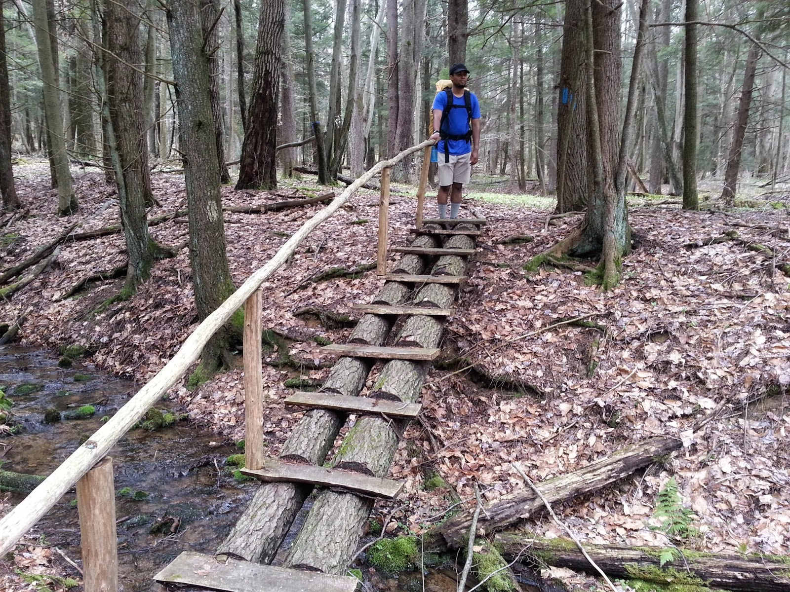
Very cool step bridge along the trail
We all found places for our sleeping areas and had another pleasant evening sitting around a nice fire.  I went out and found two more nearby caches thus putting my total found at 401 since 2005 or so.  It was nice enough for Turk (KJ) to take a swim in the creek, but I was ok with being sweaty and dirty, but I did clean up in a hiker sort of way.


Kangaroo Joe cleaning up
KJ's tent
Fire
This night we had no rain.  No, that would come during the last days hike of about 7.2 miles or so.  It actually felt pretty good as the day was rather warm once again.  We encountered a couple beaver dams on the way out, but didn't see any of the beasts themselves.  

The rest of camp
Before we knew it, we were on the last forest road before we hit Kellettville.  We spread out on the road down as KJ, with his ancient phone, tried to call John to see when he was coming to get us and let him know we were headed to the Bar for lunch and he could meet us there.  We were a little ahead of schedule, but I never make my schedule firm.  The woods and the trail dictate my progress.  Not some written down itinerary or guide book.  Turks old phone was the only one that worked during this trip.  I was able to send one or two texts to Lisa along the way, when we got high enough, but Snap's and my "smart" phones were pretty much on airplane mode the whole trip.  Only a camera in a sense, but that is ok for me.  

Oh yes, Alex decided on "Snap" as his trail name.  I added a surname for him and called him Snap Padless, but Snap fits him fine.  His photography skills are legend.  

We got down to the road and waited for Turk to finish his phone business and then we all headed over to Cougar Bobs for some lunch and a few well earned beers.  When we got in there and placed our orders with Heaven (yep, that was her name), I realized that she was the first person we had seen since leaving John at the trailhead.  We had had the whole trail to ourselves.  There was plenty of evidence of other hikers as our trash bag professed as we lugged out their trash that they left at each campsite, but no one else was hiking in our area the whole four days.  So NOT like the AT.  Comforting and scary at the same time.  


Waiting for Kangaroo Joe.  Hike complete...
Before too long, John came in and joined us for lunch and then Dave and his cousin came by as we finished up.  We headed back to Marty's for a nice shower and some clean clothes and then Alex and I headed back to Maryland as Turk headed out to his next adventure with Dave.

It was a great time and our next trip will be on ground I have already tread on my beloved AT.  Pen Mar to the Museum, July 7 to 9 or 10.  Almost 38 miles, with some much longer days planned than this trip.  Gotta keep raising the bar.  

I'll see you on the trail...

Friday, May 2, 2014

Spring AT Section Hike - Peters Mountain to Rausch Gap


Hikes the AT

My work had me needing to be in the area of the museum on Tuesday and then again on Saturday for two Earth Day events, so I decided to get a few more miles checked off for the old 2000 miler quest.  

So far, my furthest point north was Peter's Mountain Shelter just over the river and up the mountain from Duncannon, PA.  I figured I would head to the next parking lot north and hike back south to the shelter, then head north again and hike to Rausch Gap shelter.  Finally retracing my steps back to the truck on Rt 325.

Tuesday's Earth Day event was in Shippensburg at the University.  The environmental club had a nice set up and even though it rained throughout the day, I had a good time talking to the people who stopped by the table where I had displayed some information about the museum.  
Howard manning the table at the Ship U Earth Day event
When I finished up, I got some wings at Sheets and headed to the Museum.  When I was eating at the General Store table, two hikers came up.  One was Sequoia, one of our Docents who was out doing some slackpacking before he continues his Thru that was cut short last year.  The other was Rags to Riches (Rags) who was a Class of 2014 Thru Hiker.  He was very interesting and had a clever Golden Ratio theory for marking milestones of the trail.  More on that later.  

The next morning, I was up early and headed out in the dark to the parking lot that would be my starting point for this hike.  The commute wasn't too bad, even though I had to travel with all the rat packers who were going to their jobs in the Capital City of PA.  

The morning was a little chilly.  In the mid 40s, but there was a windy day forecasted and I would soon feel its full brunt.  I grabbed my pack and headed southbound on the trail.  


Rt 325 Parking Lot

The beginning was a 816 foot climb over 1.6 miles.  It was very calm as I made my way up the switchbacks to the top of the ridge.  This was a very good warm up to knock off the morning chill and before long I was sweating nicely.  Once I got to the top, I figured out why it was so calm.  These ridges (mountains) run generally in a East/West direction.  The wind was coming from out of the Northwest and boy was it a wind.  On the ridge top I was struck by the biting chill of the wind and I had to put my fleece back on to keep me a little warmer.  My pace quickened to keep the blood flowing.  

One of my tasks during this day's hike was to check out a listed campsite to see if it was suitable for the nights rest.  My plan was to hike to Peter's Mountain Shelter and then back to this campsite.  I found it quickly and it was a nice flat area with a pine needle carpet, but I was a little concerned on the wind coming over the ridge.  It was on the top of the ridge, but more on the southern side, so some of the wind was filtered by the forest.  I made the decision to come back here and see how the later day wind was fairing.

The rest of the hike to the shelter was a basic ridge walk with some good trail and a few rocks here and there.  I passed three trails that crossed the AT and got a nice vista at Kinter View along the way.  


View to the left

view to the right
Around 10:15am I reached the shelter where I had my lunch and had to put my puffy on to keep warm on the windy day.  I wanted to fill my water as there would be none until I descended the mountain in the morning, and I knew it was quite a walk down to the spring below.  In the fall when I stayed here, the spring was but a trickle that took me 10 minutes to fill my bottles.  This time when I got down, it was flowing nicely and took about 3 seconds to fill.  The walk up took 10 minutes, but I needed the water and paid the sweaty price.  


Working on my register signature at Peter's Mountain Shelter


Just before Noon, I packed up again and started back North.  On the way back I spied this interesting rock formation.  It looked like a very large rock had been split and then separated over the eons.  I wondered what it would take (and how long) to move those two pieces apart.  To me it looked like a stone giant from over on Stoney Mountain had thrown that huge rock across the valley long ago and that is where it had landed, splitting on impact.  
Split Rock - "View of the Day"
I reached the campsite around 2:30pm and after scouting a possible alternate hanging area, I decided to just set up the hammock at the established campsite and hope for the best.  

I have a small paper journal where I write my notes each hiking day and I have a template on my phone where I can type in the general details and upload to one of my sites, (if I have signal).  Below is what I wrote for day one.  

1.  Date: 4/23/14
2.  Day 1
3.  Morning temp: mid 40s
4.  Weather: windy overcast
5.  Time start: 0710
6.  Time stop and miles: 1431 11.8
7.  End point: camp near Rt 325
8.  Events: turkey flush
Log: Up and off to parking lot early. First part of hike was a climb. The rest was a windy ridge walk. Lunch at Peter's Mt shelter. Headed back north to campsite next to trail. Hope the wind dies or I may have to move over to the lee side of the ridge. Good hike good day. May the breeze blow new strength into your being.

Since I finished the hiking day rather early, I just hung out at the campsite and slowly put up my hammock.  I tried a different (lighter) ridge line for the tarp, but the prusik knots wouldn't hold, so I went back to the old trusty paracord.  I made some dinner and was in my hammock, reading while the sky was still rather bright.  And so ended day one...

The night was a typical one for me first night out.  I toss and turn in the hammock, doze and sleep lightly throughout the night.  The wind kept up throughout most of the night, but for the most part I was warm enough.  I still should have brought my underpad, but I hadn't.  By 4am or so the cold started seeping into the sleeping bag.  After a while I decided to get up and get the day started.  It was dark as I packed up my gear and the sun was just rising as I hit the trail at 6:20am.  


Day 2 sunrise
I headed back down the switchbacks to the parking lot where I had breakfast in the truck.  After restocking my food bag, I headed up Stoney Mountain.  The trail heads up the side of that mountain and eventually over to Sharp Mountain.  It is a 1100 foot climb over 3.3 miles.  It was slow going, but not too hard.  The name is a good one for Stoney Mountain.  There were the mountainside was literally covered in very large boulders.  They even used some to make small bridges over the little streams that ran down the hillside.  

Rock bridge
And the trees would grow up amongst the rocks, sometimes grabbing one and having it grow between a crock in the trees.  


Day 2 - a rock in the crock
As I headed up the trail, I came to some old roads.  This area used to have a lot of coal mines and you could see evidence of their presence in the hillsides.  When I reached the mountain top, I came to the terminus of the Horseshoe Trail.  This trail starts in Valley Forge and comes all the way over here, quite a few miles.  After taking a short break, I continued on and arrived at Yellow Springs Village around 11:30am.  This was the location of a small mining town back in the day.  The only thing left are some old cellar holes and piles of rocks that must have been the chimneys or foundations.  


Yellow Springs Village
After lunch the trail just followed the ridge top until it came to Rausch Gap.  These last four miles or so were just your regular PA rocky trail.  I continued on at a leisurely pace and arrived at the Shelter at 2:25pm.  

This shelter was pretty nice.  It had a spring flowing into a trough right in the shelter area. 


Day 2 - Rausch Gap Shelter
Shelter Spring
As I set up camp, (deciding to sleep in the shelter for the night) I noticed my right shoe had a nice rip in it.  This was going to be that pair of shoes' last hike.  I did a duct tape fix and it actually worked very well for the last day's hike.


Day 2 - Last hike for this shoe
I pretty much just laid around on my sleeping bag after dinner reading until I dozed off.  Around dusk, I heard someone coming down the steps to the shelter.  It was another hiker named Lotsa Things.  We talked a bit, and then I just rolled over and tucked myself in for the night.  And so ended day two.  Here is my Day 2 scribblings.  

1.  Date: 4/24/14
2.  Day 2
3.  Morning temp: high 30s maybe
4.  Weather: breezy, sunny, nice
5.  Time start: 0620
6.  Time stop and miles: 1425 12.9
7.  End point: Rausch Gap shelter
8.  Events: 3 mile climb
Log: The cold seeped into my body by 5. Got up around 0550. Did some jumpingjacks to warm up.  Broke camp fast and headed to the truck.  Ate bfast then headed up Stoney Mt. Long up. Was nice along ridge. Ate lunch at Yellow Springs. Got to shelter early and decided to stay in shelter tonight.

Day three dawned pretty nice.  It was definitely the warmest morning so far and even though rain was forecasted for sometime during the day, the sky was clear in the morning and I was sure I could get pretty far before any rain came in.  I cooked some oatmeal sitting on my sleeping bag, packed up and hit the trail.  Once again, just as the sun came up over the mountain. 

Day 3 sunrise
I think that on this third day, I had finally found my stride.  I moved pretty quick over the ground I had covered the day before.  I also had visions of pizza in my head and that always helps motivate me to move.  Today was the first day I could remove my fleece while hiking.  The temps were headed into the 60s and the wind was gone.  I ate lunch at an established campsite on the mountain top where a tower used to be.  All that was left were the cement supports.  


Lunch stop
I arrived back at the parking lot at 12:20pm after I had easily done the hiker goal of "10 by 12".  That means hiking 10 miles by Noon.  It is an indication that you are making good progress for the day no matter how many miles you plan on hiking.  

I was taking some pictures and I heard someone ask me a question.  It was Big Rags.  In the two and a half days I had been hiking my easy 36 miles, he had covered 55.  He was wondering if there was water up the mountainside as he looked at Clark Creek near the parking lot.  I ensured him there was plenty of water coming off the mountain.  


Clark Creek
Once again we discussed the Golden Ratio.  After some back and forth and a little calculation, we determined that the Golden Ratio point of the trail is in NY.  Right at Mile marker 1350.5, near Glenwood, NJ.  For southbounders, it is somewhere in VA.  It is another interesting way to look at the milestones of a hike.  I wrote a little more about it in my next AT Museum Volunteer Newsletter.  

I headed to town and got me some pizza and headed back to the Museum.  I took a shower down at the campground and as I finished up, the rain finally arrived.  

1.  Date: 4/25/14
2.  Day 3
3.  Morning temp: 50s
4.  Weather: clear, nice

5.  Time start: 0645
6. Time stop and miles: 1220 11.3
7.  End point: Rt 325

8.  Events: backtrack, deer's ass
Log: Up at 0545. Out the shelter after a warm bfast. Thru who came in after 7 last night wasn't stirring. Day felt good and so did I. Didn't see any sign of rain yet. Hike back along ridge seemed fast. I was back at the parking lot just after noon. Saw Big Rags again and talked more about the golden ratio. Headed to Carlisle and then Sheets, then back to the Museum. The rain started as I was taking a shower at the camp. No new miles today, but it was a good hike.


Saturday was my second Earth Day event.  This time in Waynesboro, PA.  The other significant thing that was happening that day was that Waynesboro was being designated as an AT Trail Community.  This is a big deal for towns and helps bring in business and notice.

The day was nice, with a little wind but plenty of sun.  On my way down there, I saw a few turkeys.  These two jakes wanted to cross the road and were gobbling at me to get the heck out of the way.  


It was a fun day talking to the other exhibitors and the visitors who came by the table.  We finished up around 3:00pm and I headed home once again.  Feeling good about the trail and ready for another hike.  


Museum Table

Dedication of Waynesboro, PA as AT Trail Community


Sunday, April 27, 2014

Day Three

1.  Date: 4/25/14
2.  Day 3
3.  Morning temp: 50s
4.  Weather: clear, nice5.  Time start: 0645
6. Time stop and miles: 1220 11.3
7.  End point: Rt 325
8.  Events: backtrack, deer's ass
Log: Up at 0545. Out the shelter after a warm bfast. Thru who came in after 7 last night wasn't stirring. Day felt good and so did I. Didn't see any sign of rain yet. Hike back along ridge seemed fast. I was back at the parking lot just after noon. Saw Big Rags again and talked more about the golden ratio. Headed to Carlisle and then Sheets, then back to the Museum. The rain started as I was taking a shower at the camp. No new miles today, but it was a good hike.


Day one and two were written out on the trail and uploaded when I had wi-fi back at the Museum.  Today's entry is being loaded from text I wrote at the end of the hike.  Here are some more pictures from the hike.  


Day 1 - working on my register signature
Day 1 - A real pink blaze...
Day 2 sunrise

Day 2 - a cool rock split "View of the Day"

Day 2 - a rock in the crock

Day 2 - Rausch Gap Shelter

Day 2 - Last hike for this shoe
Day 3 sunrise


Friday, April 25, 2014

Day Two

1.  Date: 4/24/14
2.  Day 2
3.  Morning temp: high 30s maybe
4.  Weather: breezy, sunny, nice
5.  Time start: 0620
6.  Time stop and miles: 1425 12.9
7.  End point: Rausch Gap shelter
8.  Events: 3 mile climb
Log: The cold seeped into my body by 5. Got up around 0550. Did some jumpingjacks to warm up.  Broke camp fast and headed to the truck.  Ate bfast then headed up Stoney Mt. Long up. Was nice along ridge. Ate lunch at Yellow Springs. Got to shelter early and decided to stay in shelter tonight.
Rausch Gap Shelter

Spring Section Day One

1.  Date: 4/23/14
2.  Day 1
3.  Morning temp: mid 40s
4.  Weather: windy overcast
5.  Time start: 0710
6.  Time stop and miles: 1431 11.8
7.  End point: camp near Rt 325
8.  Events: turkey flush
Log: Up and off to parking lot early. First part of hike was a climb. The rest was a windy ridge walk. Lunch at Peter's Mt shelter. Headed back north to campsite next to trail. Hope the wind dies or I may have to move over to the lee side of the ridge. Good hike good day. May the breeze blow new strength into your being.

Trail Register at Peter's Mountain Shelter

Friday, March 28, 2014

What's In a Trail Name?

I have come to love the Trail Name part of the Hiker World.  I have a lot of fun with it, both in naming myself and talking to others about their names.  

You can find a lot of stories and information on the Interwebs about trail names, but I haven't found yet any definitive origin of the trail name.  In some of my readings I have seen that other groups (like fraternities and sororities) use nicknames and since a lot of the hikers nowadays seem to be college age or just out of college, maybe that was a natural extension of their nicknaming. 

Regardless of the origin, it is a very popular part of hiking the trail and isn't just a Thru Hiker thing.  Anyone who gets out there is able to take on a new moniker that they can take with themselves along the trail and beyond.  Its popularity has grown along with the number of people who hike the trail.

To add on to what Larry Luxenberg said,  I remember reading that Earl Shaffer called himself "The Crazy One" and later "The Original Crazy One".  I think the meaning and origin of that one is evident as no one believed he was doing what he was doing and it took him a while to convince the ATC that he completed a Thru Hike.  

Here are the reasons I have seen for Trail Names.  It is a fun way to take on a new persona while hiking the trail.  You can shed your "Real World" life and take on the Outdoorsy life along with a new name.  You can name yourself (but don't tell the purists that) or a name can find you along the way.  The one caution is, a name that finds you may not be as flattering as you want it to be, but if you are a good sport, you can go with it.  One thing I have seen that a person who constantly vetoes suggestions, ends up with the trail name Veto.  :)

For me, like I said, I like having fun with my trail name.  The trail has named me and so have I.  You get to think about a lot of useless things while out walking all day, so during this time I came up with my own Guidelines for Trail Names.  I call them "Joe's HYOH Completely Non-Purist Guidelines for Trail Names".  Only I follow these rules, but I like to explain them to others when I tell them I have several names (and one really long, strung together name) and I can interchange them or add to them at any time I feel like it.

Guidelines:
1.  I can have up to 14 trail names at one time.  
2.  I can add or delete to my trail names whenever the urge comes to me.
3.  If I find a 15th trail name, I must select one to delete from my trail name list.
4.  I can string my names together if I want and make one super long trail name.
5.  I can create my own names.
6.  I can accept suggested names, if they fit.
7.  If the name fits, even if it is unflattering, I should always consider accepting it in the spirit of the name game.
8.  Do your best to help others find their Trail Name(s).
9.  Keep having fun, no matter what.  As Model T says, "Find the Happy Side of Misery".  
10. Everyone is entitled to a Trail Name.  Even if they are out for a day hike.  NO ONE has a monopoly on Trail Names.

And that is if for now.

Sincerely
EarthTone
aka
El Jefe Maestro Obi Wan, the EarthToned Stiller Fan