Sunday, February 25, 2018

Monthly Hike - February Edition

Monthly Hike for February

The back end of February had arrived and it was time for another hike. Without realizing it at first, I had made a New Year's Resolution of trying to get out into the Outside for at least a night or two each month of this year. For the last couple of years I have been intrigued with winter hiking and have been dipping my toe in a few times over the last couple of years and was ready for some more.

A few weeks ago, I picked the week after Valentines Day for another trek on the AT and started checking the weather forecasts. I had decided to head up to Boiling Springs and hike north, through the Cumberland Valley and up over Blue Mountain and then Cove Mountain before descending into Duncannon, then turn around and hike back. I checked the weather, not as a go/no go decision, but to know what I would need to handle any challenge. Luckily, the time I picked would have two unseasonably warm days that spoke more to Spring and even early Summer instead of Winter.

At first, I had planned on crossing the Susquehanna and heading up the other side to Peter's Mountain, but as soon as I was out there a day, the plan gelled into what it became. A four day out and back of 55.3 miles.

The mission of this hike would be to hike the 1.6 miles from where the trail turns just before the Doyle, through town and across the Juniata River. This small section is the only part of the trail in PA that I haven't hiked yet. It was time to officially finish PA.


Day 1: The Valley


I headed out early on Skysday, the 30th of Solmath. The temperature was a brisk 37 degrees on my truck thermometer, but it was forecasted to go up into the mid forties during the day with rain a strong possibility. The region had received a fresh dumping of snow a day or two ago, but most of it had melted.


First blaze of the trek

I had to drop off some books at the AT Museum, so after doing that and heading over to the ATC office to get my parking pass and meeting Sarah, who was on duty when I stopped by. I drove to the parking lot, parked, hefted my pack and was "on trail" at 0900 sharp.

The beginning was nice. What snow that was left was scattered about and it was fast going for the first two hours. Mostly level terrain, with a mix of fields and forest. After a couple miles I realized that I had left my knee bands in the truck. Oh well, I'd make due.


Break time at an old cemetary

When we got near the creek, it started getting more muddy and I slowed down some. I found a sea to summit pack cover on the trail and picked it up. I figured I would find the owner at the shelter. I ate lunch at Scott Farm and started up the last part of the day where I would be challenged by the only climb of the day. It had started to sprinkle as I got close to the farm, so at lunch, I put the cover on my pack. I might as well take advantage of it if I'm carrying it. I should have put my rain jacket on too, but waited and my fleece got pretty wet.


Passing over Rt 11. Carlisle in the distance. 

As I got up in elevation and crested Blue Mountain, the snow lay deeper here. The shelter basically sat in a cloud as I arrived at 1533. It was empty of course, but I found a couple of trees to hang.
Snowy, foggy view from the shelter
The shelter has four bunks and the posts between the two looked sturdy. I paced off the distance and thought it may work. I put up my hammock there and it did work. I was prepared to move if others arrived, but if I could avoid hanging above snow, I was going to.


Solo Darlington shelter setup

I prepared dinner and went about my chores, hanging up my damp hiking clothes and setting up my bed. The forest grew dark and no one else arrived. I hunkered into my quilts and dosed off to the sound of dripping water which would be continuous throughout the night.


Wet gear

Log Entry:
Valley
Date: Skysday, Solmath 30
Day 1
Morning temp: 37
Weather: overcast, later rain
Time start: 0900
Time stop and miles: 1533/14.6
End point: Darlington shelter
Hike time: 6 hours, 33 minutes
Avg mph: 2.2
Flora: bright green water plants
Fauna: pileated woodpecker
High: back on the trail
Low: mud
Hope: sun


Tibetan prayer flags in the Taj Mahal privy


Day 2: Into Duncannon

After my usual first night restless sleep I rolled out sometime after 06. We had been in a cloud all night and everything was wet. My quilt and hammock had a good sheen of wetness and my wet clothes from yesterday were as wet as when I took them off. No worries as it was not too cold and there was no wind. A lot of the snow had melted overnight.
I packed up, ate and did the morning routine and was heading out at 0730. The terrain wasn't too bad. A little up and down. My right knee didn't feel happy, so I tied my bandana at my knee to simulate my forgotten band. It would help throughout the hike.

Sleeping beech tree
I stopped for lunch at Cove Mountain shelter. I had forgotten how much of a downhill it was to the shelter. The trail down to water was pretty steep too. I just filled up about 3/4 of a liter, which would be enough to get to town. The sun came out after lunch and it started getting warm. I started to dry out and took off my damp fleece after a while. Hawk Rock had a nice view and before too long I was walking into Duncannon. I walked into the Doyle and got a beer, then I got a room.

View from Hawk Rock
I cleaned up then went down and ate some wings. After that I walked the final 1.6 miles through Duncannon that I had to do to finish PA. I went back to the Doyle and had a burger and more beer. Everything is drying in the room. My left baby toe is acting up again. I had to drain it this time.


The one, the only, Doyle

Log Entry: 
Fog then Sun  
Date: Seasday, Rethe 1
Day 2
Morning temp: 42
Weather: fog, wet
Time start: 0730
Time stop and miles: 1345/14.8
End point: Doyle-Duncannon
Hike Time: 6 hours, 15 minutes
Avg mph: 2.2
Flora: sleeping ferns
Fauna: red tailed hawks, red wing blackbirds, squirrel
VOD: Hawk Rock
High: beer
Low: blister
Hope: a good hike in the am


Day 3: Heading Back

I slept pretty good in the small room. There was a small gas heater in the wall and it kept the room toasty and all my gear dried out.
I was up before 06 and slowly packed everything up. I went across the street for some breakfast at Goodies. It was schmeckt lecker (Delicious). I went back to the room and threw on my pack. I had taken some of my extra food and hiker boxed it and since I knew where all the water was I only needed 1 liter to start. I packed my fleece, so my load was still up there, but not bad at all. I moseyed my way out of town, reading some of the interesting info plaques that were here and there. This sleepy town used to be some big shit back in the day. Producing kids sleds and lots of nails. Soon I was heading back up the mountain towards Hawk Rock. It was what I thought would be my hardest climb of the day, but it turned out to be not too bad. I just went slow, taking my time. When I was almost to the top I came upon a scene. Three cold Blue Moon bottles sitting in the middle of the trail. It wasn't even 0830 yet, but I didn't hesitate to take one. I finished the climb and enjoyed the breakfast beer as I took in the wonderful view from the overlook.

Breakfast beer trail magic on Hawk Rock
The rest of the day was just moving along the ridge, then heading down to the hay fields before the final climb to the shelter. Those fields had activated my hay fever when I last hiked them in June of 2013. They were sound asleep and cut short now. I stopped often for short breaks throughout the day. The pipeline view at the end of the rocky section was nice, where the day had become a beautiful one. I took a nice lunch at the creek where I filled up both liters. It was hot enough to take my shirt off and rinse it out in the fast moving stream. It was even sunny enough for me to wish I had brought my sun screen. I continued along after my last break at a camping spot .7 from the shelter. I had one more climb of the day of about 450 feet. Going up that hill kicked my ass. I stopped often and kept pouring water into my belly, but I was spent. But like everything else out here, eventually you get to your destination. All you have to do is keep putting one foot in front of the other. It's amazing how that works.

Hot enough to go shirtless for a bit during lunch
I had only seen one other person out there during the day and he was just walking his dog. The shelter was empty. I shrugged off my pack and started the transition to camp. It was still early in the day, but I was glad to be stopping. My toe blister had progressed to a large flap of skin, but it really wasn't too painful. I cut off the skin with my handy dandy knife scissors and put a small bandaid on with some AAA ointment to cover the raw looking wound. I decided to go down to the spring and fill up a liter. It was a bit of a walk down, but the spring was flowing good. Right as I got back to the shelter it started to drizzle a little.

Just as I was eating dinner, with only about an hour of daylight left, a hiker came into camp. He was a young man with a small daypack who was just out for an evening's walk. His name was Nickolas. We discussed mushrooms and other wild edibles and other things that strangers talk about when they meet out in the woods. He had a small black wooden flute that he showed me. After he left, as darkness surround the shelter, I could hear him playing his flute as he made his way back down the mountain It looks like I will be walking in the rain again tomorrow as these outliers of a large storm pass over like a preview of what's to come. No one else showed up so I snuggled into my quilts once again, not worrying about the intermittent rain showers that would plink off the roof during the night.

Log Entry:
Heading Back
Date: Earthday, Rethe 2
Day 3
Morning temp: 52, later 80
Weather: calm sunny warm
Time start: 0725
Time stop and miles: 1420/11.4
End point: Darlington shelter
Hike Time: 6 hours, 55 minutes
Avg mph: 1.6
VOD: Hawk Rock
High: Hawk Rock beer
Low: That last climb
Hope: I don't get too wet tomorrow

Day 4: A Walk in the Rain


I rolled out of the hammock at 0630 the next morning. The first thing I did was zip on my pant legs. I had slept in my hiking pants after unzipping the bottoms that were covered in mud. I had forgotten that I was in shorts during the night as my quilt was keeping me plenty warm and was surprised when I got up to pee sometime in the night.

It's strange at that shelter. The sky never got dark enough where I couldn't see the trees. It glowed a low yellowish gray all night long. I'm guessing Cumberland Valley is a bright valley. PA's Capitol, Harrisburg is just down the river to the south, which the shelter faced.

Yesterday's spring like warmth was gone, replaced with a brisk wind that tried to steal my heat. I headed out with a lighter pack as I was once again wearing my fleece and also donned my rain jacket in anticipation of the rain I knew I would have to walk through.

Today would once again be a pretty easy 14 plus miles. All I had to do was descend Blue Mountain to the valley and cross its fields and small forests back to Boiling Springs on the other side. The rain started fairly early in the day and stayed with me until the end. Most of the time it was mist like and I couldn't feel that it was raining, but my jacket would be covered in drops. The cheap plastic rain jacket would do a wonderful job of keeping me mostly dry and protected from the wind. The hike was far from strenuous, but I would work up a sweat from time to time as I negotiated the flat, but muddy trail.


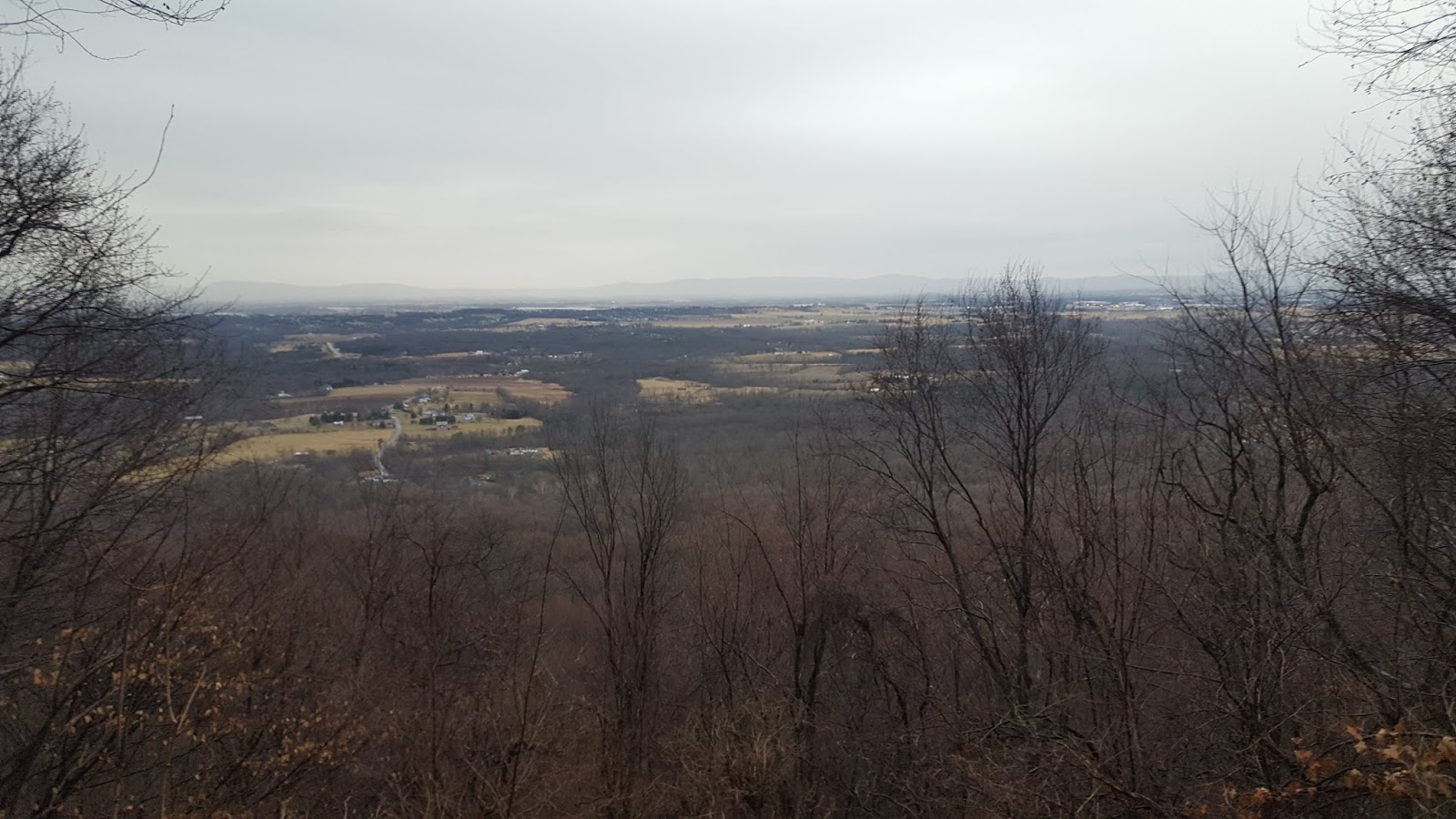
View into Cumberland Valley from Blue Mountain

I stopped for water at the spring about a mile from the shelter and again at Scott farm. I ended up eating lunch at the old cemetery I had rested at three days ago. Today was just a day of walking through the rainy PA Cumberland Valley. It was just as enjoyable as the sunny day as long as I kept myself dry, which I did. My pants got a little wet, but that never bothers me. I just made sure my phone was in its protective waterproof pouch (which limited photos and video) and moved along the trail until it was time to turn onto Route 174 at Boiling Springs.

I walked back to the truck and threw my pack into the back. I returned my parking pass to Sarah at the ATC and set my sights for home. Of course I stopped at the nearest Scheetz for a personal pizza and something to drink, before heading home to a warm shower and a soft bed. Back inside again.

Hiker Trash - Hike complete
Log Entry:
Walking in the Rain Date: Starsday, Rethe 3 Day 4 Morning temp: 39 Weather: Cold, windy, drizzle Time start: 0740 Time stop and miles: 1430/14.5 End point: Boiling Springs
Hike Time: 6 hours, 50 minutes
Avg mph: 2.8 High: The hot shower once I got home Low: wet feet Hope: That I will get back out in March once again


Final Thoughts

Hiking in the winter is an interesting experience. The trail seemed almost empty as I moved along from Boiling Springs to Duncannon and back. On the first day I saw several day hikers out, trying to get some trail time in on the holiday with the weather not too bad. The next day, I wouldn't see another hiker until I was almost into town.

The experience repeated itself over the next two days as I headed back. Only seeing one or two other people out there experiencing the trail in winter. The solitude is nice, but for me, too much of it starts to transform into loneliness. I was glad that Nicholas stopped by the shelter for a while that last night as it was good to share some stories with another like minded being.

These short trips are fun. A new challenge to experience. Being out here for a long duration would be very wearing on the mind and body. Much props to those who have already started their long hike. I still think I prefer the warmer months of the year though.

I liked how I once again quickly fell into the rhythm of the trail routine. I have processes for just about everything out there, from packing to making my meals to setting up and taking down my hammock. It is comforting to know that I can jump back in and get into the groove quickly.

With these short hikes though, the body just starts the process of acclimation, that for me, usually takes around two weeks to completely adjust. I like the daily workout and the soreness of my feet and muscles is actually welcome. Kind of like seeing an old friend again, but I'm only starting to get used to it all before the hike is over.

My feet are testing me on these short hikes. I keep getting a blister on my little toe. My feet have to also go through their process to become hardened to the daily grind of walking all day. I come home, the blister heals insteads of toughens and the process repeats on the next hike.

I'm looking forward to that time, later this year, when I will have been out on the trail again for a couple weeks and my body has started to loose its "winter weight" once again and I'm used to getting up and walking all day, every day for miles and miles over mountains and into gaps.

Until then, I will keep going out each month at a different part of the trail that I have already walked, but is nearby. Getting my Trail Fix and becoming an Outsider once again, if only for a short while.

Peace,
EarthTone


Thursday, February 15, 2018

Hiking My Own Hike


Hiking My Own Hike

Yes, I know that phrase is so overused, but, for me, I now think of it as a useful phrase that has many meanings.  Sort of like the versatility of the word fuck, it has come to be used in several different situations.

But I'm not here to discuss how I've come to think of HYOH as a semi passive-aggressive, faux polite way to say "shut the fuck up", but to explain my desire to make my hike a personal journey.  


An Obsession is Born

Since around 2010 or so, my interest in the Appalachian Trail has grown into an obsession. I have even spent three years extremely immersed in the Trail Culture that surrounds the trail from north to south, when I was the manager at the A.T. Museum in Gardners, PA.  The more hikers I met of every style there are, the more I wanted to make my hike something unique.  I didn't want it to fit into the cookie cutter shape that certain hikes have become over the years.  I wanted something special.

One day, as I was daydreaming about the trail, an idea came to me that this hike could be a Quest.  Being a fantasy nerd, a Quest seemed the only proper way to complete a full traverse of the trail. But what would this Quest entail?  

I started feeding my obsession in 2011 by doing a nine day section hike from Harpers Ferry north into PA, the state of my birth.  I hiked about 90 miles that time, starting to learn how hard it was to hike several days in a row for decent mileages each day.  I learned that my feet would hurt when you hike like that.  I learned that when the weather is concerned, you take each day as given.  You soldier on, no matter what, because there are miles to go before you sleep.  As soon as I finished that hike, I was planning my next.


At the Halfway point in 2011. The obsession begins.

So, as the next several years went on, I would pick a part of the trail that I hadn't hiked yet, and go out for three or four days, or a week or so.  Adding to my measly total of unique miles until I had about 15% of the trail complete.  


LoGear and I doing a section in northern VA in 2012


Accepting the Quest

In 2016, after recovering from a back injury that had me not only cancelling hiking trips, but walking with a cane for several weeks, I saw a window in 2017 where we could get a very large chunk of the trail walked, if not the whole thing.  The Quest was becoming reality.  Once we picked a time and place to start, the more times I said it, the more real it became.

My wife, LoGear was up to the challenge and would come along.  We picked late April for our start, as we had some responsibilities to complete before the window opened.  We would hike north as far as we could.  As far as Pamola would let us. 

If you have read any of my other writings here, you would know that Pamola is an ancient storm god who lives in Katahdin, the greatest mountain.  He has the head of a moose, the body of a man and the wings and talons of an eagle.  Being a storm god, he has the ability to control the weather.  Especially on the mountain where a peak bears his name.  I had learned about Pamola while working at the Museum and became fascinated with him and his story.  

Pamola

Before too long, my Quest had a name and along with the task of walking the whole trail, I had a very important additional task to fulfill the Quest, now named Pamola's Quest.

In my fantastical daydreaming, I had come to believe that Pamola had come to me and assigned me the Quest.  I would walk all of the trail, gathering the elements of the Talisman of the Storm.  A powerful amulet of Pamola's that had become scattered from Georgia to Maine many years ago.  I would find these elements as I hiked along.  Gathering them together and rebuilding the broken Talisman.  I would deliver the completed Talisman to the famed storm god on Pamola Peak on top of Katahdin.  There I would receive my reward for completing the Quest.  I'm still not sure what that reward will be.

The elements of the Talisman would be small things like pebbles and nuts. Feathers and bracelets and anything that revealed itself to me as an element of the amulet.  I would know when I found one most of the time.  The way it usually worked is I would notice something as I walked along.  A small shiny stone or a perfectly round nut.  A bracelet waiting for an owner or a feather laying in the middle of the trail.  I would usually pick it up, put it in my pocket and forget about it for a while.  Later, I would come upon it as I fished in my pocket for something and remember.  If it was still there, I would move it to my electronics bag or the pouch of the amulet itself.  A new element of the Talisman would be added. 


The Talisman at its beginning

So we started this Quest like the other thousands of wanna-bes who start their adventure in Georgia.  At the beginning, it had the potential to be a Thru Hike, but that was never my main goal, or very important to me.  If it ended up being a Thru Hike, than all the more special, but I had decided that I would not give the completion of my Quest a time limit other than the span of my life or walking ability.  If it took more than the standard year, than so be it.  I knew going in that the odds were certainly not in my favor, but I just needed to get out there and become a long distance hiker.  Outsiders, who are living life on the Trail, traveling by foot, as far as we could go.  


At the Arch.  4/25/17.  I'm really fat.

After hiking 251 miles, LoGear had come to the realization that my Quest had become less important to her than seeing her daughters and our dog.  She decided to get off trail after we left Erwin, TN in late May.  I continued on alone, but when I walked into Damascus, VA. I knew that Phase I of the Quest was coming to an end.  I needed a break.  I had let my mind convince me that I didn't want to spend the WHOLE summer just walking all day, every day.  I needed a diversion.  I needed something that wasn't walking all day, every day. I knew we would be back, but I wasn't sure when or where.


Alone on the trail for a while


Entering VA. 30 lbs lighter

End of Pamola's Quest Phase I


Doing Other Things - And Hiking

I got "off trail"  (no one quits, we just get "off trail")  and went home.  I planted my garden, kissed the cat, harvested my garlic, opened the pool and we went down to the beach for several days.  It was good getting back to the variety of things I do every summer, but before too long, we were talking about getting back to the trail.  


Ginger and LoGear in Cape May

In early July we headed back to the Trail. Not where we had gotten off, but close to where we might have been, had we kept walking.  We got back "on trail" at Rockfish Gap, and hiked through Shenandoah National Park.  It was an awesome hike.  We moved along good even though we had lost most of our trail legs and the weather was much more hot and humid in July than it had been in May.  We met new hikers and even saw a couple that we had started with down in GA.  But, this Phase (Phase IIa) was only eight days as now we had things to do at home before I could return once more.


Back "on trail" in Shenandoah

Shortly after getting home the first time, I found that our heat pump wasn't doing too well and I had the HVAC guys come in and look at it.  They put some dye into the system to check for a leak and were coming back soon to see what was up.  Also, during our first hiatus, I purchased some Tom Petty tickets, so we now had a date in Philly to see one of the greatest rockers of my young adulthood and I was still a huge fan.  Once I heard of Tom's passing, I knew that getting "off trail" was the totally right thing to do.  I had been wanting to see him for several years and am thankful that I got to see him during his last tour, even though we didn't know that was the case at the time.


Tom Petty and the Heartbreaker in Philly, July 29, 2017

After the concert, LoGear drove me up to Lehigh Gap in PA which was the northernmost part (excluding short hikes in NJ, NY and ME) that I had hiked in my Section Hiking days.  From there I continued north to finish PA, then NJ, NY and CT.  Getting to within four miles of the VT border in MA.  At the end of August, I headed home once again finishing Phase IIb of the Quest.  


Climbing up out of Lehigh Gap with Scrambles and Grouch, two hikers we had met in NC
who came walking up to me 5 minutes after I had restarted.


Phase III

When everyone is ramping up for Trail Days in Damascus, VA this May, I will be heading back to the Trail to finish the Quest in two more Phases.  Starting in Damascus I will hike north to Rockfish Gap to finish my 11th state.  After a short break, I will head back up to Williamstown, MA and will finish the final three states heading north.

Once I complete the AT, I still haven't completed my Quest.  The plan is to continue along the Knife's Edge to Pamola Peak, where I will present my completed Talisman to the god who sent me on this Quest.  If I am found worthy, I will continue down the Helon Taylor trail, down to Roaring Brook campground and from there, make my way to Millinocket and then home.  Or, maybe I'll just keep hiking.  I don't know.   


The Talisman of the Storm after Phase IIb


Present Day and The Quest So FAr

So here we are on day 296 of the Quest.  I ended up hiking 910 new miles of the Trail in 2017 and when my Quest evolved into something that was not a Thru Hike in early June, when my lack of mental fortitude allowed me to decide to get "off trail" for a time, I decided to include the 15% of Trail I had hiked from 2011 thru 2015 for a total of 1299 miles complete and around 990 to go.  I have collected several elements of the Talisman and I know that I only have a few more to find.  

I am perfectly happy with the way this hike, this Quest, has progressed.  Once I let go of the time constraint that a Thru Hike entails, a huge pressure lifted from my chest.  Some people become obsessed with being a Thru Hiker.  I'm not one of them.  I'm hiking MY own hike and I'm ok with that.  

I know this is a long read, so if you are still here, thanks for sticking around.  I have had a hell of a ride so far during this Quest and I am sure that once this Quest is complete, my Adventures will be far from over.  LoGear will still keep hiking new miles and I hope will one day become a 2000 miler in her own right, so it will be fun hiking with her and supporting her as she does the miles.  I have also already started planning my next Adventure which will be a traverse of the state of my birth, PA, on foot, using the multitude of trails that exist in my favorite state.

Stay tuned.  I guarantee it will be a wild ride.

Peace,
EarthTone