1. Date: 5/8/15
2. Day 6
3. Morning temp: 60. Later 81
4. Weather: Cool in am with some clouds, then sunny.
5. Time start: 0705
6. Time stop and miles: 1035. 6.1 Miles
7. End point: Ohiopyle - End of trail.
8. Events: Grouse drumming, 1 slip on down hill
Log: Last day. It was a very nice morning and we were ready to finish. We headed out together, but I had some issues with the gps app and got behind. There were two decent climbs, followed by two steep declines, but before we knew it we were back at Ohiopyle, where we had caught our shuttle six days ago. It was a great hike.
It was another clear, cool morning and the final day of our hike. We arose at 6 and got ready for the day. Today's hike would be the shortest day of the week at only a little over six miles. There were two 600 foot climbs each quickly followed with a 600 foot down hill.
We actually headed out at the same time today, both ready to get on the trail. This whole hike I had been running the app Map My Hike during the whole hike in the attempt to get a gps track of the whole trail. So far, it had worked very well and I had decent tracks of all five days so far. I had also been taking gps tagged pictures of certain landmarks, like road crossings, streams and power lines. I had also photographed all the mile stones (except 62, don't know how I missed it) and I had acquired a good deal of data on the trail. I had also figured out that the best maps are the old topos at the back of the old Laurel Highlands Trail guide. It was easy to figure out where I was with a glance at the little maps. Today, my app wouldn't start tracking, so KJ moved on as I fiddled with my phone. Eventually I just fired up a backup app that would gather the data I needed for the day, but the lady in my phone wouldn't be announcing milestones as the day wore on.
 |
| There be Dragons |
 |
| A Warning? |
 |
| Trillium |
 |
| A whole hillside of Trillium |
 |
| May Apple Flower |
 |
| Resting at Rock Spring Run |
 |
| Bluets |
 |
| Last View |
Finally, we were at Mile Post 1.
 |
| Thumbs up from KJ. One mile to go. |
 |
| Stick Pic Photo |
 |
| The final stairs |
 |
| Mmmmm, beer... |
 |
| All done |
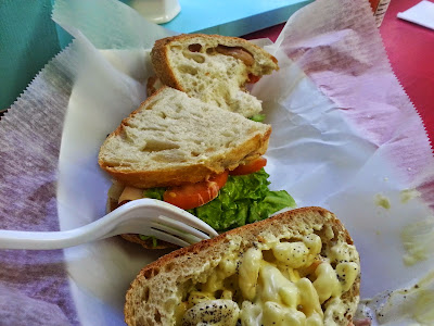
We found a little sandwich shop and proceeded to have a very good post hike lunch. I normally don't take pictures of my food. (ok, I do from time to time), but when I saw this huge clove of garlic baked into my bread, I had to snap a pic to show my bride.
It was delicious.
 |
| Turkey and cheese on a garlic loaf with mac salad as a side |
After lunch, we parted ways. KJ still had some days off left and he was headed to his cabin. I had to get home and then get back to work at the Museum. Our busy season was starting.
Not ready to head home yet, I went back over by the outfitters and walked around their store again. I say Crash, our shuttle driver and talked to him for a bit. As we were talking a girl sitting on the bench asked me if my shirt was an ATC shirt. It was of course and I had a nice conversation with Pheonix, who is from Carlisle and had volunteered at the Mid-Atlantic Regional Office of the ATC in Boiling Springs. She was now working as a raft guide I think. These people here seem to really be living the dream.
After our nice talk, the Pub had opened and I headed over for a celebratory PBR.
This hike was awesome. I highly recommend it. It take some planning and you have to stick to your itinerary and pay for the shelters, but it was all worth it.
In a few days, I will try to make another post about the gear I brought, what I used and what I just carried. Some of that stuff I will still carry as I see it as emergency gear, but other stuff I will probably leave behind.
Thanks for following along.
EarthTone (Wrong Way Joe)
Day 1 - Day 2 - Day 3 - Day 4 - Day 5 - Day 6
1 comment:
Great story! Can't wait to do a thru hike myself! !
Post a Comment